

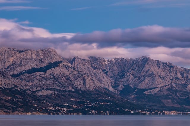
Which neatly leads us to one of the special features of the Dinaric Alps: their almost exotic differentness that begins merely six hours’ car journey from Munich. The naked karst scenery characterises this most expansive and, thanks to its ruggedness, almost impassable mountains of the Balkan peninsula. Their designation as Dinaric Mountains is practical really but not quite correct. Strictly speaking, this name is reserved for the tectonic-geological substructure which is not identical with the mountains.
Where exactly are the Dinaric Alps?
The Dinaric Alps were named after the Dinara Mountains in Croatia as well as Bosnia and Herzegovina. They stretch from the southern foothills of the Eastern Alps in Slovenia and Italy around 700 kilometres towards the South East along the western side of the Balkan peninsula. The conventional boundary with the Alps is at Postojna Gate close to the Slovenian capital Ljubljana.
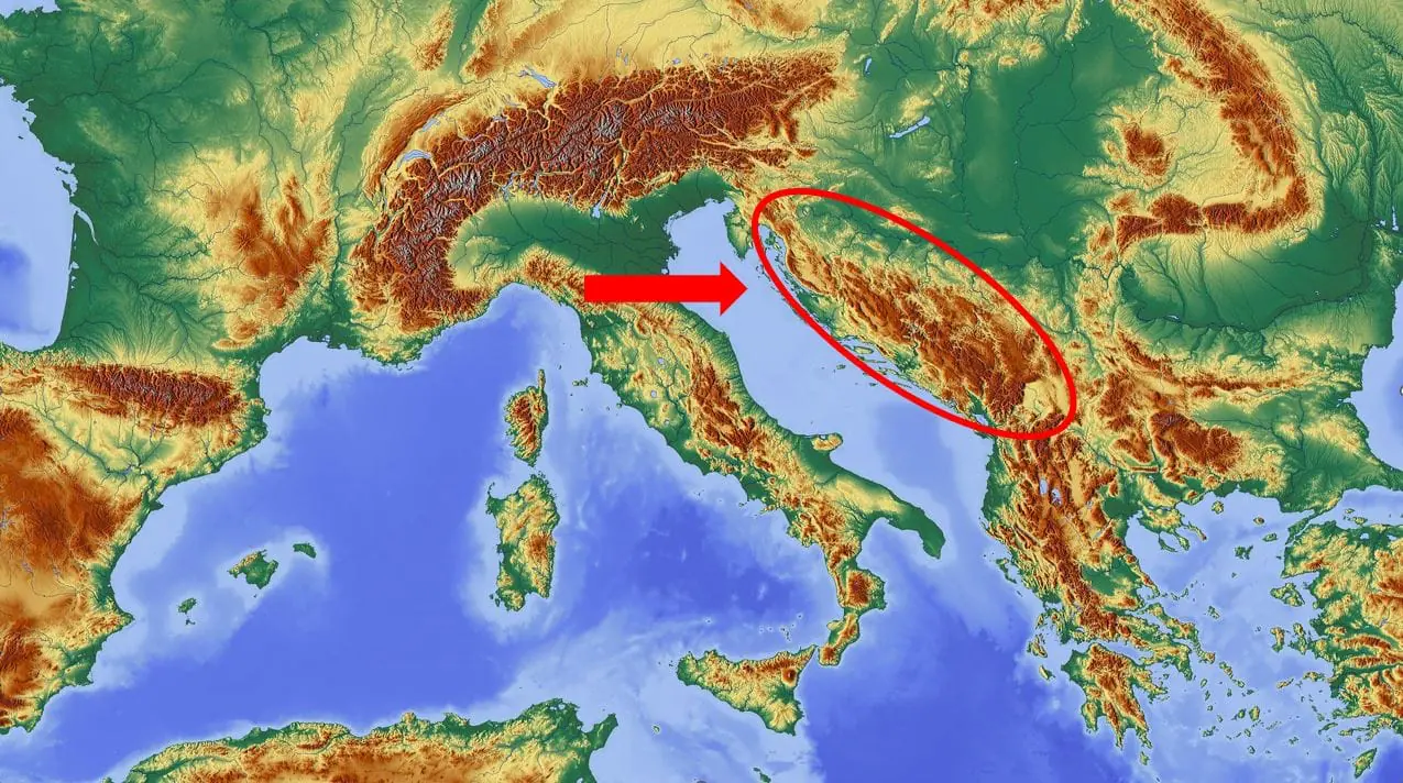
From there, the Dinaric Mountains extend with a wedge shape that becomes wider towards the South East. The natural boundary in the North East is the Pannonian Plain that crosses Serbia and Hungary. The south eastern end is around the most northern point of Kosovo. From there, the “base” of the “wedge” runs along the border of Serbia, Kosovo and Montenegro for about 350 kilometres towards the South West to the Adriatic Coast. As the mountain range increases in width from the North West to the South East, it also increases in height, culminating in the plateau highlands of Durmitor and the Alpine landscape of Prokletije (Albanian Alps).
At the Croatian Adriatic Coast, the range turns back towards the North West to Postojna Gate. The many Mediterranean bays and islands on the way (Krk, Brač, Hvar etc.) are also part of the Dinaric mountain system. Owing to the tectonic activity of the Adriatic Plate, earthquakes occur quite frequently; sometimes they’re incredibly strong.
Character and special features
In terms of topography and morphology, the Dinaric mountain range can be attributed to the fold or fault-block mountains in the North West (Slovenia, Croatia, Bosnia) and the plateau or dome mountains in the South East (Herzegovina, Montenegro, Northern Albania). This basically lists most of the seven countries in which the Dinaric Alps are located. Serbia and the most north western part of Kosovo complete this list.
Transnationally, the diverse karst shapes and landscapes are likely the “top trademark” of the Dinaric Alps. Many globally applicable names of karst geology have actually been derived from local names there. “Polje”, for example, describes a flat basin surrounded by rock walls or faces. Very large poljes sprawling across a hundred square kilometres and more can be found in the South of Croatia and adjacent areas of Bosnia.
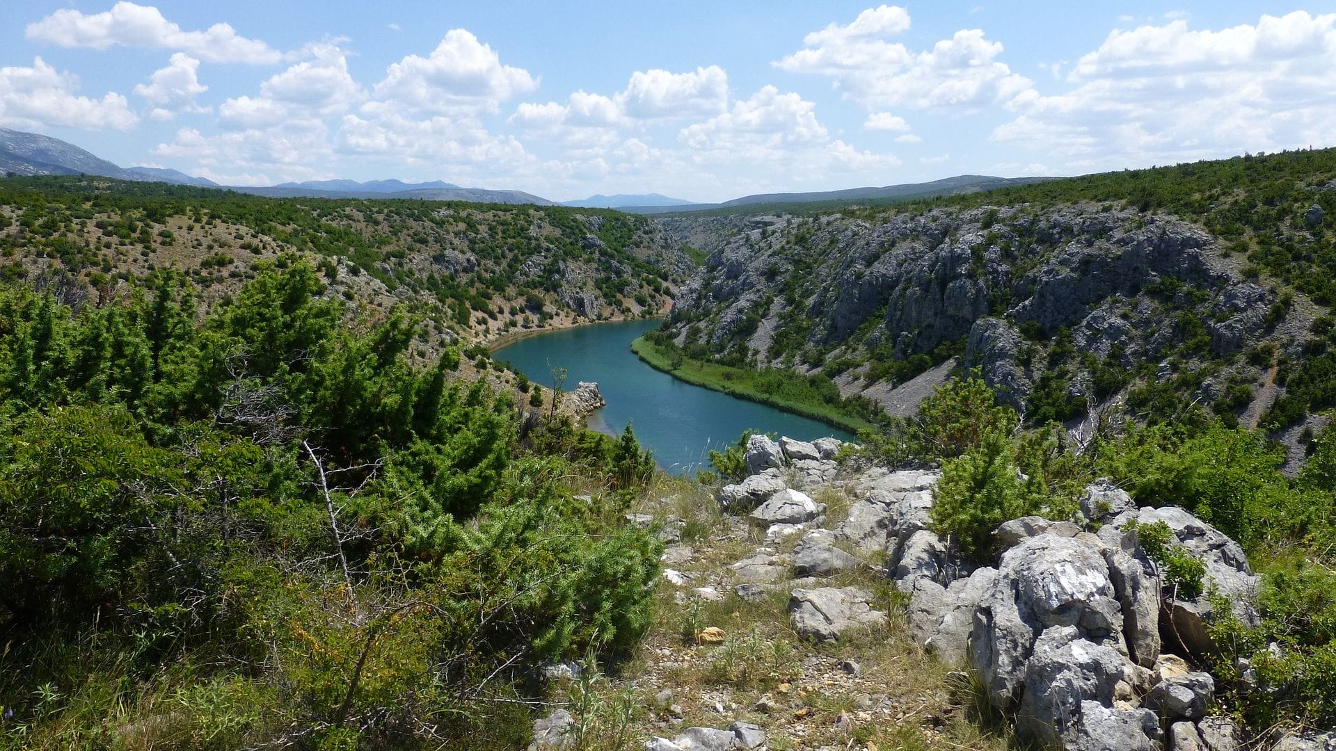
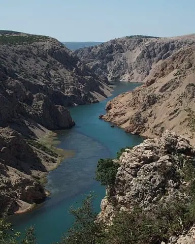
In addition to ubiquitous distinctive rock formations, geology has shaped many rift valleys in the form of inaccessible canyons. They developed after the mountains folded, running from the centre of the Balkans usually in a western and southern direction to the Mediterranean. Transverse valleys common to other mountains often don’t exist here, which is why these long rift valleys only offer limited options for access and development. This is exacerbated by severe fissures in the landscape. These are barely less pronounced in the lower and flatter areas than at higher altitudes. This makes the Dinaric Alps a real traffic barrier between the Mediterranean region and the centre of the Balkans.
The differences between this mountain region and the Alps is quite extraordinary if you consider their proximity. Furthermore, it’s much less developed and frequented by visitors, and extensive areas are hardly populated or not at all. This means there are still regions everywhere in the Dinaric Mountains where large mammals like bears, wolves and lynxes can live without being disturbed. The following rule of thumb applies: the further away from the coast, the “wilder” and less known.
Climate
With their spread of about 600 kilometres to the North and South, the Dinaric Alps are part of several climate zones. In the West, the Adriatic has a Mediterranean influence, bringing mild winters, hot summers and copious quantities of rain in the winter, with 5,000 mm/year and more in parts of Montenegro that are situated by the coast. The fact that the landscape, with its many naked rocks, looks rather dry is more down to the water seeping away quickly than to the climate, despite its dry and hot summers. This also applies to many other “semi-desert” or “steppe-like” regions in the Dinaric Alps.
The opposing force to the Mediterranean coast is the continental landmass of the central Balkans. This is where cold and dry air comes from, which causes harsh winters as well as hot summers. Where damp air from the Adriatic meets much colder continental air in the winter, a lot of snow will fall.
Thanks to the great range and variation of landscapes and regional climates, the Dinaric Mountains boast very diverse flora and fauna.
Leftovers from war: mines and lost places
The war in Yugoslavia may have been over for decades but traces of it can still be found everywhere in the Dinaric Alps. The fronts and battle fields were largely located in these rugged, complex mountains. In Bosnia and Herzegovina, the most fought over republics, around one million mines were buried between 1992 and 1995. Vast amounts of ammunition were also left behind. Around 200,000 mines and unexploded bombs have not been cleared yet. The exact numbers cannot be determined because many mine location plans were destroyed during the war, and mine fields created by paramilitary units are not documented.
In addition to Bosnia, Croatia is also still blighted with mines, though to a lesser extent. The good news is that areas attractive for hikers have generally now been mapped in a way that unsafe zones can be avoided, thanks to various warning signs. Those sticking to signposted, marked hiking trails most likely don’t have anything to worry about. In areas that are rarely frequented and barely developed, you should employ a local guide. Unfortunately, it’s necessary but advisable to find out more about the mine situation in advance, in particular in Bosnia.
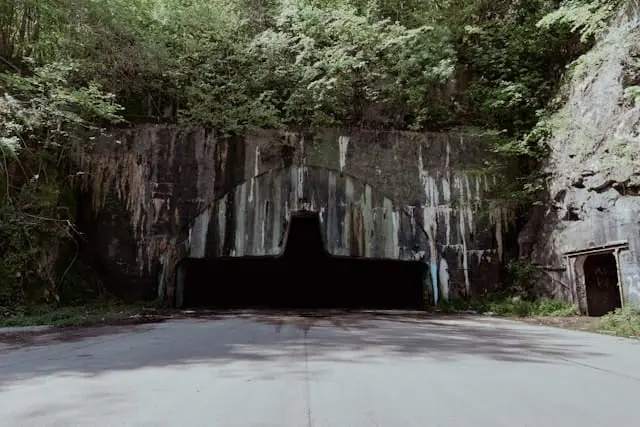
However, the war hasn’t only left mines behind but also abandoned aircraft hangars and other military facilities. Travellers from all over the world are fascinated by these “lost places”. A very impressive example that can be reached relatively quickly from the Alps region is the former military air base close to the Croatian village of Željava at the border with Bosnia. This military hangar carved into the mountain between 1957 and 1970 was the biggest in Europe with space for 1,400 soldiers, 80 fighter planes and 110 pilots. But with its extensive size and eerie “top secret” atmosphere, it’s no longer an insider tip.
A similar, but not quite so well-known ghost hangar from the Yugoslavian Tita era can be found at the other end of Bosnia in Gnojnice close to Mostar.
How high are the mountains in the Dinaric Alps?
High mountain ranges in the Dinaric Alps are, from the North West to the South East, the Velebit Mountains on the Adriatic (up to 1,757 m) and the Dinara Mountains along the Croatian-Bosnian border (up to 1,837 m), which have given the whole area of the Dinaric Alps their name. In the central and southern tip of the Bosnian heartland, there are numerous mountain ranges running in a longitudinal and transverse direction to the main axis, as well as plateaus reaching 2,000 metres with gorges carved into them (mainly around the urban centres of Sarajevo, Mostar and Jablanica). The highest mountain in Bosnia and Herzegovina is located at the border with Montenegro in Sutjeska National Park (Maglić, 2,389 m). The scenery in many parts of the Bosnian Dinaric Mountains is wild and beautiful, yet still not discovered by tourists. This area is quite popular with offroad riders on two and four wheels. Numerous narrow, winding and often unpaved roads offer great adventures.
The highest mountains in the Dinaric Alps categorised by country:
Slovenia: Veliki Snežnik, 1,796 m
Croatia: Dinara, 1,831 m
Bosnia and Herzegovina: Maglić, 2,389 m
Serbia: Pančićev, 2,017 m
Montenegro: Bobotov Kuk, 2,523 m
Kosovo: Zborište, 1,546 m
What hiking trails are there in the Dinaric Alps?
From Slovenia to Montenegro, there are signposted trails everywhere as well as regional and local networks of paths in all prominent parts of the Dinaric Mountains. All worthwhile and attractive trails easily fill several huge walking guide books. Situated near the coast, the mountain ridges Velebit in the North and Biokovo in the South of Croatia are particularly appealing and even spectacular in places. In Paklenica National Park, Velebit features a traditional, internationally popular climbing area and the Tulove Grede massif. It was a key backdrop in the Winnetou films and still attracts many fans. The elevated hikes in Velebit offer unique views into the depths as well as panoramic vistas, thanks to the contorted coastal sections with numerous promontories and islands.
With their many waterfalls, the Plitvicer Lakes situated “behind” the Velebit Mountains in the Croatian borderland close to Bosnia are known not only as a unique natural spectacle but also as another Karl May film backdrop (“Treasure of Silver Lake”).
Mountains and more mountains
The Biokovo Mountains rise up impressively steeply above the Adriatic beaches and feature the “Skywalk”, which is a steel balcony protruding an immense 1,200 metres above the Mediterranean. This artificial yet breathtaking attraction is located around 6 kilometres from the seaside resort of Makarska. Of course, this amazing karst landscape can also be enjoyed without these additives – whether on a simple hike on the high plateau or some more challenging climbing on solid vertical rock faces.
Another world-class, more well-known hiking destination includes the Durmitor Mountains in the most southern part of the Dinaric Alps. In this blog, I have already extensively presented this absolute gem. Less or not at all well-known areas are described on what must be the most comprehensive Dinaric Alps website: Dinarskogorje. The English version is still being developed. One example of an unknown area with great adventure potential includes the Bosnian Bjelašnica Mountains which accommodate the legendary pristine mountain village of Lukomir with its remote, dramatically beautiful location. More about that and about hiking in Bosnia in general can be found on the Asecretcalledbosnia website.
Long-distance hike: Via Dinarica
The most popular hike in the Dinaric Alps is their complete crossing. The Via Dinarica runs from Slovenia through seven countries “down” to Northern Albania. The main part crosses Bosnia and Herzegovina, which is why it’s said to have great potential for adventures and exploring. The “White Trail” is the “main trail” which follows the highest summits of the Dinaric Alps. Comprehensive information about the White Trail and about other routes can be found on Outdooractive’s Via Dinarica platform.
A section of the “blue” Via Dinarica via the already mentioned Biokovo Ridge is also described there.
An overview of hiking routes in all of the Dinaric Alps is also available on this platform.
What other activities can be pursued there?
The question should be what outdoor and tourist activities are not possible in the Dinaric Mountains. From climbing (classic: Paklenica) and offroading by jeep and motor bike (secret tips: Bosnia and Montenegro with the Sinjajevina and Maganik mountains), mountain biking, canyoning (mainly Montenegro) to rafting and kayaking on river rapids – everything is possible. Even a respectable city and culture programme could be arranged, thanks to the long and eventful history of the region.
Tourist information
The countries adjacent to the Dinaric Alps offer all possible types of tourist infrastructure and services – depending on the region, from highly developed to rudimentary, from high to low quantity and quality.
Clear information about how to get there, travelling locally, best time to travel, red tape, mountain and rescue huts, weather conditions, mountaineering associations, mountain rescue services and useful links can be found on the Dinarskogorje site mentioned above. That site also offers a collection of more or less easily available Dinaric Alps maps.
Link tips
Nestvarna.blog: Serbian Alpine blog with amazing photos of the Dinaric and other Balkan mountains. Unfortunately, an English translation can only be selected for some parts. For the rest, a browser extension is required. Then lots of info and suggestions for other adventure sports, such as ski touring, kayaking or canyoning is available.
Our packing list for day trips detailing everything you need for the perfect day’s hiking (not only) in the Dinaric Alps


