

A Hint of Mystery

Like many mountain ranges that once lay behind the Iron Curtain, the Caucasus retains an air of mystery. Unless you’re a mountain enthusiast, you may only know that Elbrus, at 5,642 metres, is its highest peak. Well into the 21st century, the region remained remote and not entirely safe for travellers. Even today, areas such as Abkhazia, South Ossetia and Dagestan remain difficult to access.
Europe or Asia: Where Does the Caucasus Belong?
The Caucasus is often considered part of Europe. For mountaineers pursuing the Seven Summits challenge, Elbrus – not Mont Blanc – is recognised as Europe’s highest peak. Yet the continental boundary is frequently drawn along the Bosphorus, the Black Sea, the Don River and the Ural Mountains. By that definition, the Caucasus lies firmly in Asia.
In truth, there is no definitive answer. Both geographical and cultural arguments support either classification. The most balanced perspective is to view the Caucasus as a transitional zone, blending elements of both continents.
The Highest, Most Iconic and Most Dramatic Peaks
Elbrus, at 5,642 metres, is a dormant twin-peaked volcano cloaked in glaciers. It rises dramatically above the surrounding mountains, about 20 kilometres north of the main Caucasus ridge in the western part of the range, entirely within Russian territory. Encircled by smaller fold mountains, it stands like a commanding presence.
Few Western climbers are familiar with Dych-Tau, the second-highest peak, located roughly 60 kilometres east-southeast of Elbrus, also in Russia. At 5,204 metres, with vast icy flanks, it is a formidable sight. The third-highest peak is Shkhara, just five kilometres south of Dych-Tau, straddling the Georgian-Russian border. At 5,193 metres, it is Georgia’s tallest mountain. This ice-clad giant marks the eastern end of the Bezengi Wall – a dramatic 10-kilometre-wide barrier of rock and ice that towers up to 2,000 metres above the Ulluchiran Glacier on the Russian side. Adorned with hanging glaciers, ice shelves and fractured walls, it is crowned by peaks nearing 5,000 metres. On the Georgian side, the mountains plunge just as steeply, forming an equally imposing wall known locally as Khalde.

With Elbrus, the Bezengi Wall and their surrounding peaks, nearly all of the Caucasus’s five-thousanders are clustered in close proximity. One exception is Kazbek, located 120 kilometres east-southeast. This 5,033-metre dormant stratovolcano is perhaps more widely recognised, thanks to its iconic silhouette behind the Gergeti Trinity Church – arguably Georgia’s most famous postcard image. Its relative accessibility also contributes to its popularity, allowing many climbers to reach the coveted 5,000-metre threshold.
The Most Beautiful of Them All
Many regard the dramatic twin peaks of Ushba as the most beautiful mountain in the Caucasus. Standing at 4,710 metres, it may be lower than the region’s giants, but it is far more challenging to climb. With its sheer faces and ice-crowned double summit, Ushba presents an irresistible test for elite alpine climbers.
(* Spellings and names of mountains and places in the Caucasus vary widely across languages and scripts. For simplicity, I use the most straightforward Latinized versions here, without claiming absolute accuracy.)
Geology, Climate and Natural Environment
The Caucasus was formed by the collision of the Arabian Plate with the Eurasian Plate, which compressed and uplifted the Earth’s crust. Around 25 million years ago, this process of bulging, folding and erosion reached its peak. The ongoing tectonic activity has created complex fault lines and geological tensions, resulting in earthquakes, volcanic activity, hot springs and rich deposits of natural resources.
Climate
The Black Sea plays a major role in shaping the climate of the western Caucasus. It brings a subtropical climate to the coastal areas and heavy rainfall further inland. In early summer, moist air masses rise along the south-southeast slopes of the Greater Caucasus, triggering frequent thunderstorms and storms along the main ridge. The northern and eastern flanks are drier, colder and more continental. For mountaineers, the weather across the Caucasus poses a serious challenge, especially on the towering four- and five-thousand-metre peaks.
Flora and Fauna
Much of the region’s ecosystem remains intact, supporting a rich and partly endemic biodiversity. Mountain forests of beech, oak and conifers are often dense and impenetrable, while summer meadows bloom into vibrant, waist-high carpets. Alongside numerous bird species, the area is home to chamois, wolves and brown bears.

Culture and History: A Tapestry of Diversity
Thanks to its central location, the Caucasus has served as a strategic crossroads for major trade routes over thousands of years. Countless tribes, ethnic groups and peoples have passed through and settled here. The result is a complex and eventful history, shaped by waves of prosperity, conflict and cultural exchange. Today, the region is home to more ethnic groups – each with its own language, religion, traditions and lifestyle – than anywhere else in such a compact area.
However, this rich mosaic has also led to divergent and sometimes conflicting territorial claims and political or religious ideologies. Many of these tensions were long suppressed under Soviet rule. After the collapse of the Soviet Union, they flared up in the form of wars and lawlessness across the newly independent states. It was only around the turn of the millennium that relative stability began to return.
How to Reach the Caucasus
For most Western mountaineers, Georgia is the natural starting point. This small, diverse country is currently stable and relatively easy to access. Entry requires only a passport, and flights are affordable and not overly long. Overland travel via Turkey is also straightforward for those with a passport and a taste for adventure.
The Russian side is less frequently visited, not only due to political factors and limited space in this article, but also because of higher bureaucratic barriers and lower interest among Western tourists. The notable exception is Mount Elbrus, which attracts many climbers aiming to complete the Seven Summits. The website Mountain-Level offers a detailed travel report from summer 2023 that provides valuable insight into this expedition.
Azerbaijan, the third country with a share of the Greater Caucasus, is not covered here due to limited information and space.
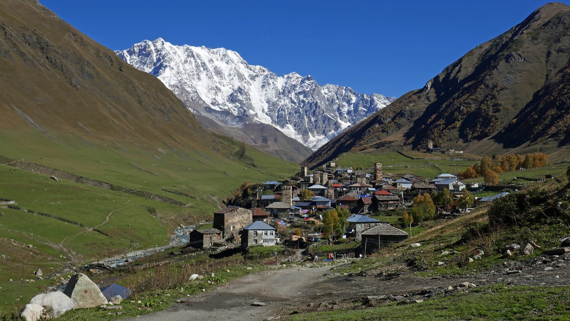
In Georgia, the Svaneti region is by far the most popular destination for Caucasus travellers. With its towering peaks and the town of Mestia at its heart, it serves as the tourist hub of the region.
Getting Around: The Marshrutka System
Svaneti is accessible via minibuses known as marshrutkas, which run directly from the major cities of Tbilisi and Zugdidi to Mestia. These services operate on informal schedules, with departure times typically shared by word of mouth. Journeys often begin late if the vehicle is waiting to fill up with passengers. Apart from rest stops and terminal stations, there are no official stops. Marshrutkas will pull over when flagged down, but if the bus is full or the driver chooses not to stop, you may be left waiting by the roadside.
From Mestia, Ushguli can be reached in just over an hour for a fixed fare of 40 lari (GEL). In summer 2024, this was roughly €13 – a fair price for the 40-kilometre journey. The Mitsubishi minivans used on this route are noticeably more comfortable and less crowded than standard marshrutkas.
A quirky detail: Japanese import vehicles are popular in Georgia and often feature right-hand steering, even though traffic drives on the right. This oddity is a fine example of Georgian improvisation!
Northern Side Valleys of the Inguri Valley: Pricey but Spectacular
Costs rise significantly if you plan to hike or trek in the stunning northern side valleys of the Inguri Valley, also known as the Mestia main valley. For instance, the 25-kilometre journey from Mestia to Mazeri in the neighbouring Dolra Valley costs around €35 one way. The breathtaking scenery and trekking opportunities come at a premium. The same applies to the more remote but equally scenic Nakra Valley.
Communicating lesser-known destinations or unusual requests in English can be difficult, especially with older drivers and ticket sellers. English is a genuinely foreign language here, and fluency should not be expected.
In my case, hitchhiking worked once without even raising a thumb. A friendly construction worker in a Japanese mini-truck stopped of his own accord, saving me five kilometres on a dusty road.
Accommodation in Svaneti
High transport costs are largely offset by the abundance of budget-friendly accommodation. Until late July, it’s possible to find a clean double room in a cosy hostel for around €10. Dormitory beds start from roughly €6. Financially, camping offers little advantage. Many places can be booked via booking.com. In Ushguli, which mainly attracts day visitors, and in smaller villages, the best approach is to ask around locally. From early August, tourist hotspots in Svaneti become crowded, reducing availability and driving up prices.
Food and Drink
Mestia and Ushguli offer plenty of good, affordable restaurants and snack bars, with meals and drinks typically costing between €5 and €10. Supermarkets and shops, however, are surprisingly expensive and not well-suited to backpacking needs in terms of product range and packaging. It’s wise to bring trekking food and ready meals from home.
Svaneti Highlights and Suggested Tours
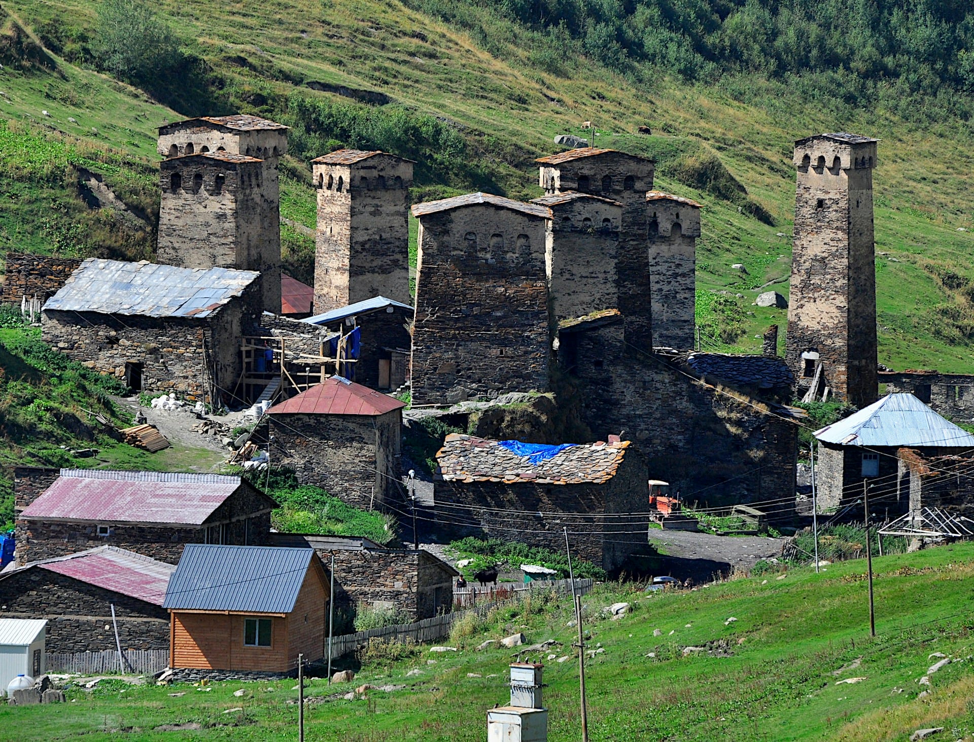
Some might call Mestia the ‘Chamonix of the Caucasus’, though it’s a far less polished and orderly version. The town is well worth a visit, if only for its distinctive skyline of defensive towers reaching up to 25 metres. These multi-storey stone structures once served as refuges for family clans during raids, feuds or invasions. Today, they are still used to store grain and valuables.
The following tour suggestions are a personal selection of lesser-known routes designed to showcase the region’s majestic mountains and landscapes up close. For more information on popular treks, the website Caucasus-trekking.com is an excellent resource – especially for Western readers interested in Georgia.
Trekking Routes Around Mestia
The most famous and widely travelled trek in the Caucasus is the four-day route from Mestia to Ushguli. Thanks to the villages and hostels along the way, it can be completed without tents or camping gear. August is peak season, so expect crowds.
This route can be extended westward into the Mestia-Nakra Trek, which leads to the main village of the pristine Nakra Valley.
Mountain and Hiking Tours Around Mestia
Zoruldi Ridge
This picturesque ridge south of Mestia is easily reached via the Hatsvali chairlift, making it an ideal choice for your first day in the region. The tranquil forests and alpine meadows offer sweeping views of the surrounding landscape and the main Caucasus range.
Koruldi Lakes and Koruldi Ridge
The Koruldi Lakes are a cluster of small mountain pools set on a plateau at 2,700 metres. Unfortunately, the upper section of the trail is a dusty track used by off-road vehicles and minivans, with tours widely advertised along Mestia’s main road.

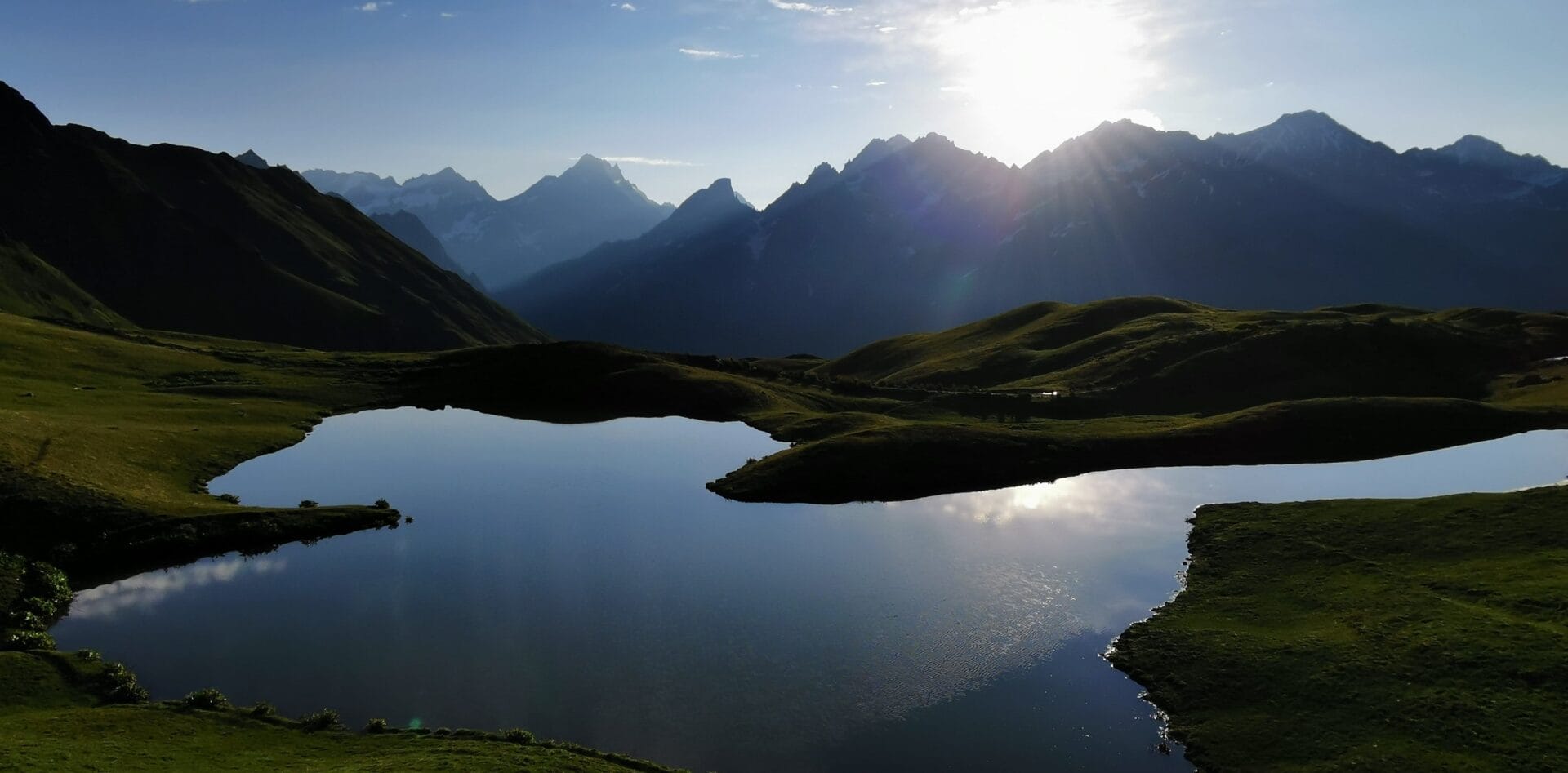
Despite the heavy footfall, the area is well worth visiting, especially if you camp overnight. In the evening stillness, the lakes become mirrors reflecting the majestic mountain scenery. The experience is even more rewarding if you continue along the gravel track the next day to its end at around 3,100 metres. From there, several paths lead to the Koruldi Ridge, marked by a summit cross. The ridge offers a breathtaking view of the towering Ushba (4,710 m) and the surrounding wilderness of glaciers and deep ravines. The terrain becomes steep and exposed near the top, so for a safer ascent, avoid the main tracks and take the left-hand detour into a hollow. This leads to a more strenuous but secure scree slope that reaches the ridge just below the summit cross. I’ve marked this alternative route on Outdooractive (track visible after registration).
Chkhuti Ridge
This varied and scenic hike follows a gracefully curved ridge and can be shortened to suit your pace. It begins along the Mestia–Ushguli Trek and is clearly signposted. At the first junction, follow the large clearing to its end, then bear right until you reach another expansive and stunning meadow. You can walk to the small wooden church at its edge to soak in the atmosphere, but the actual trail discreetly enters the forest to the left before the second clearing.
The path soon climbs steeply until the forest thins and you reach open alpine terrain. The ridge continues to rise, offering spectacular views of Tetnuldi’s pristine ice pyramid (4,850 m), although it’s often obscured by midday clouds. All the more reason to keep climbing. Experienced hikers can even attempt the summit of Kakhiani (3,702 m).
Mountain and Hiking Tours Around Ushguli

Ushguli, Georgia’s highest village at 2,100 metres, is famed for its skyline of defensive towers. These, combined with the imposing south face of Shkhara (5,193 m), create a strikingly archaic scene. At the base of Shkhara lies the gateway to the Shkhara Glacier, a popular destination. Most visitors reach the end of the valley by Mitsubishi minivan or horseback, sharing the route with dust-spewing concrete mixers from the local gravel plant.
Despite this, the following two hikes are long, challenging and wonderfully remote. Both can be shortened or extended into two-day adventures, with unforgettable nights spent camping by mountain lakes, on ridges or even summits.
Chubedishi Ridge (3,153 m): Endless Views and Summits
Looking out from Ushguli into the Inguri Valley, the grassy and scree-covered peaks of the Chubedishi Ridge rise to the right. This hike follows the ridge and can be tailored to your stamina. Most hikers reach the first summit and return, enjoying panoramic views from nearly 3,000 metres. For a more ambitious journey, continue along the ridge’s chain of 3,000-metre peaks. When the vast south face of Shkhara and its 4,000-metre satellites come into view, descend to the left. This descent leads to a small mountain lake with excellent camping spots. With luck, you’ll catch Shkhara’s reflection shimmering on the water. Below the lake, you leave the solitude of the highlands and re-enter the bustle of the Inguri Valley.
The track for this tour is available on Outdooractive.

Karetta Ridge and Summit (3,524 m): Realm of the 5,000-Metre Peaks
This route is even more demanding than the Chubedishi traverse, but it promises a dreamlike experience for seasoned hikers – weather permitting. From the Inguri Valley, turn left before the gravel plant and enter a side valley leading to the Lagem Pass. The trail narrows and fades as you climb. Below the pass, it becomes steep and eroded in places. From Lagem Pass, follow the ridge without a marked path, cross the Karetta Pass and approach the icy giants. In the distance, Elbrus sparkles beyond the border peaks. At the Karetta summit, you’ll be awestruck by the row of 5,000-metre peaks forming the Khalde Wall.
From Lagem Pass, follow the ridge without a marked path, cross the Karetta Pass and approach the icy giants. In the distance, Elbrus sparkles beyond the border peaks. At the Karetta summit, you’ll be awestruck by the row of 5,000-metre peaks forming the Khalde Wall. This tour is also rewarding if you end at Lagem Pass. If camping on the ridge or summit, you’ll need to collect water from streams below or melt snow from the snowfields. For the return, retrace your steps, as alternative routes shown on maps and apps lead into difficult terrain and trackless thickets.
I’ve created the track for this tour on Outdooractive (viewable after registration).
Refreshment Tip
Cafe Lemi, perched on the slope leading into the Inguri Valley, is the perfect place to round off your hiking adventures around Ushguli. The homemade food is delicious and reasonably priced, and the atmosphere is warm and welcoming – which, in Svaneti, isn’t always guaranteed.
Fun Fact: While hiking in Georgia, you’ll often find yourself accompanied by dogs that appear out of nowhere and vanish just as mysteriously. Sometimes they’re small and endearing, other times large and imposing. Think of them as unofficial guardians, keeping bears and wolves at bay.
Other wild and much-praised mountain regions east of Svaneti include Racha and Khevsureti.
What Else Can You Do in Svaneti?
Outdoor activities in Svaneti are centred around hiking and trekking. Beyond that, options are mostly limited to off-road excursions and noisy quad or motorbike rides. Adventure sports like rafting are offered occasionally, usually by higher-end hotels.
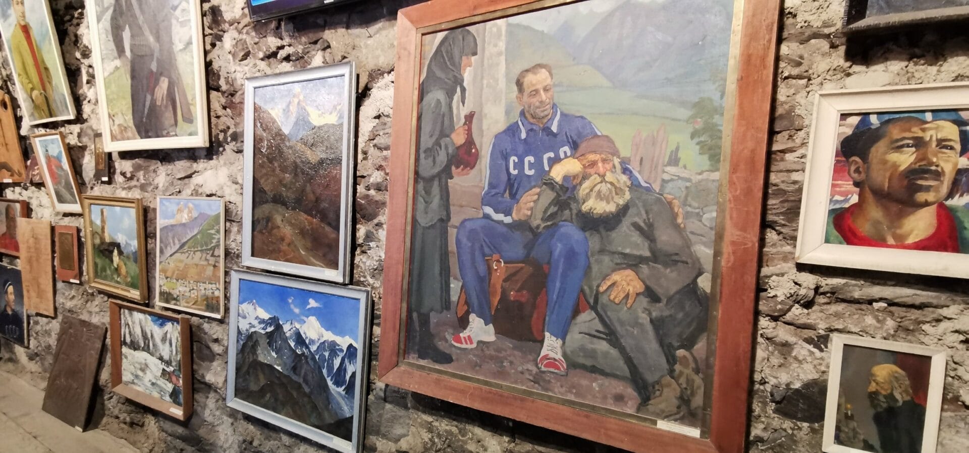
A top recommendation for rainy days or rest days is the Khergiani Museum. Located at the far end of Mestia in a historic stone house beneath a climbable fortified tower, the museum honours legendary Svan mountaineer Chumlian Minan ‘Mikhail’ Khergiani, born here in 1932. Renowned not only for his extraordinary climbing skills, Khergiani also saved many lives as a mountain rescuer.
If you’re looking for a break from the mountains, Mestia offers two ethnographic museums and the chance to watch Dede, the only film ever made in Svaneti. In summer, concerts, dance performances and film festivals add to the cultural calendar. Otherwise, cultural experiences are mostly limited to visits to fortified towers and small churches.
Final Thoughts: The Caucasus is a true treasure trove for mountain lovers with a spirit of adventure. The easiest way to start exploring is with a visit to Georgia’s Svaneti region.
Link Tip: Svanalp.com is a well-designed website run by a local Svaneti mountaineer and guide offering hikes and summit tours, including Kazbek. The focus is firmly on the mountains of Svaneti and leans more towards alpine-style adventures than Caucasus-trekking.


