
“It is a strenuous walk with plenty of ascents and descents. Parts of the route across open moorland can be difficult to navigate in poor weather – this and the isolation of these sections can make following parts of the route hazardous. The Beacons Way can be walked in its entirety in about 8 days but could easily take twice as long as there is so much to explore and enjoy en route” (en.wikipedia.org).

You’re probably wondering why I’ve chosen to begin this post with a quote from Wikipedia. Well, these few lines couldn’t describe more accurately just what our fellow Alpine Trekker Jan had the pleasure of experiencing first hand in August of 2012.
Anything is possible

How does one get the idea to choose Wales of all places as a destination for a a multi-day walk? True, the West Highland Way in Scotland is probably the best known option amongst the long-distance footpaths on the island, but I have to admit I’m more drawn to the unknown. I have this unrelenting urge to discover, you know, that urge to take the road less travelled. And, the few hundred people per year who dare to tackle the Beacons Way (according to various forums) can’t be wrong about it, can they? The ability to read a map and compass is generally regarded as essential for this route. And, because of the extremely variable weather conditions, thick mist and sink holes off the official route, the walk promises to be quite the adventure. And finally, the national park itself is supposed to be stunningly beautiful, provided the sun is shining.
Maybe I’ve just watched too many shows with the famous adventurer Bear Grylls, you never know. But, when I read that British special forces regularly train in the Brecon Beacons National Park, where the long-distance footpath is located, I was hooked. The terrain apparently takes such a physical and mental toll on you that the place is absolutely perfect for such military training.
Preparation is good, improvisation is better
From London, I travel by train to Cardiff, stay there for a night in a hostel and continue on to the small town of Abergavenny, the official starting point of the trip. Wait, what am I even carrying on my back? Well, I’ve got my 65L rucksack, which contains my tent, sleeping bag, sleeping mat, warm fleece clothing, waterproofs and provisions for 7 days. You can also find a packing list for trekking here. I’ll be cooking my grub with alcohol, which I have to buy there. My plan is to be self-sufficient, at least for most of the way. Also very important: I’ve got the maps for the region: the Ordnance Survey Maps OL12 & OL13 on a 1:25,000 scale as well as a compass and a GPS device for tracking. As it turns out, it was a good idea to take a few survival essentials as well, such as a flint, parachute cord, a pocket knife and a small roll of duct tape, all of which was protected by a large rain cape – but more on that later.
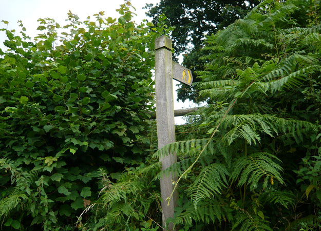
The route

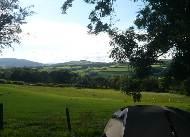
On the first day after walking up under a snuggly blanket, I head out on the route, which takes me over the ‘Holy Mountain’ (486m above sea level) up to a small place called Llanthony, which amounted to about 20 kilometres in total. It’s here that I choose to spend the night, alone at a campsite. Up to this point, the weather has been so-so. I haven’t been able to enjoy any real views so far, but I have got a taste for the very wet moorland and am now trying to arrange myself with the pathfinding. After a wrong turn and a long detour, I decide to look at my map more often! The official markings along the route seem rather scarce, but every couple of hours, I see one out of the corner of my eye, hidden away by some overgrowth, which makes me want to jump for joy every single time.
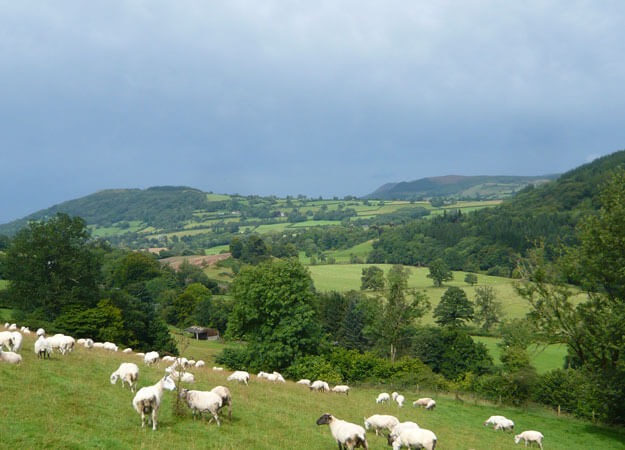
 After an average night’s sleep, I make myself some warm milk and oat flakes. My little alcohol stove needs a relatively long time to make this happen, especially in comparison to modern gas stoves, but the system weighs next to nothing and has been serving me well since my time in the service. With the sun shining down upon me, I continue my journey past small, medieval villages, ruins from the 11th century, through lush green undergrowth to Crickhowell. After pitching my tent, I sit down in front of my stove, make myself a bag of noodles and study the map. Although there is a relatively large campsite in the village and a few tiny bed & breakfasts along the way, I hardly meet a soul. On the plus side, I was able to enjoy the weather without a worry in the world as well as some fantastic views over the Brecon Beacons. I hope this continues!
British weather ‘at its best’
Nothing against the British, but the rumours are true: when it rains here, it pours. Even trying to get up when it’s bucketing down like this in temperatures around 13°C is a tall task. Soon, I meet a Welsh man on the street and timidly ask what the weather is going to be like, but all he can give me is a grin full of pity and only an inkling of hope for sunshine come afternoon. So, I decide to spend the morning off the beaten track and follow the less exposed ‘Brecon Canal’ to the village of Llangyndir (yes, some of these place names are real tongue twisters. Of course, no one understands me when I say where I want to go…).
Convinced that I have discovered one of the more beautiful spots on the map, I continue for a few more kilometres to find the sun beaming its rays on me on the last climb of the day! Reinvigorated, I pay a visit to the ‘Talybont Reservoir’, on the northern shore of which there is a youth hostel of sorts with campgrounds and an outdoor education centre. At least, that’s what it appeared to be. And although I find a warm kitchen there, I decide to eat my own food first. After all, I’d rather not find out later that I’ve been lugging all this stuff around for nothing.
Day 4 – the highest peak
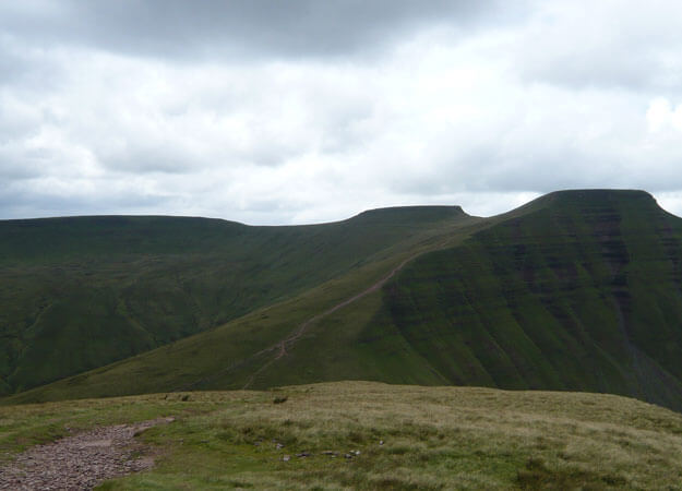
This section of the Beacons Way is officially described as ‘strenuous’. The weather is dry, albeit cloudy, and offers the best conditions for the 27km-long stretch. But, it’s not the distance that is the problem, but it’s the elevation gain. The route takes me through forested areas with moderate ascents at first, but very soon the path becomes extremely steep. After about 1 1/2 hours, I reach the central mountain range in the Brecon Beacons National Park and arrive on the first plateau, at which point I see some soldiers marching toward me at a pretty good clip. Visibly exhausted and carrying an incredible amount of kit, they torture themselves up and down the mountain. Amazing.
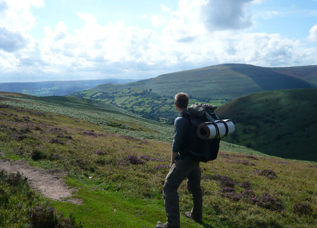
Even though I’m now standing beside a large number of day walkers on the Fan y Big (719m above sea level), there’s a short moment of silence, allowing me to take it all in. My gaze wanders over the expansive, green, hilly landscape and I estimate that I can see about 20-25km in the distance. This is exactly what I came here for! Before I continue, I grab another slice of pumpernickel as a pick-me-up. The path takes me down a steep descent, then straight up Pen y Fan, which is 886m above sea level and thus the highest peak in southern Wales. I take a quick glance behind me, only to see dark and ominous clouds on the distant horizon. I pick up the speed to reach the summit at least somewhat dry, but alas, this hope of mine quickly dissolves.  Suddenly, I can see less than 10 metres in front of me, and after reaching the summit obelisk, I have serious trouble finding the way back down. Finally, by the skin of my teeth, I manage to find my way down despite the torrential rains. Heavily eroded paths lead the way into the valley where I reach a place called ‘Storey Arms’. After half an hour of waiting, nobody shows up, so I decide to go to a catered hut about 2km off the path, which not only gives me the opportunity to dry all my gear but also has something warm to eat! Plus, I get to enjoy a bottle of wine or two with a German family and two Scottish hikers. I couldn’t dream of a more beautiful end to such a long, difficult day.
Life is full of surprises
Yeah, so not only am I’m really lost, rain and dense fog are expected to last the entire day. Great…and just this morning, I was told I shouldn’t go hiking today. Did I listen? Of course not. With a slight hangover from the night before, I thought it would be best to keep moving…
So, now I’m standing in the middle of this boggy, heather-clad plateau like a fool, cursing Mother Nature for this awful weather. My compass is showing me the general direction, but I am more than an hour away from anything that remotely resembles a trail. The last sign, if I’m not mistaken, was a cairn about one kilometre back. So, I follow my instincts and slide about 50 metres down a steep, muddy slope full of sheep dung. Great… Not only am I soaking wet, I’m covered with…ugh, you know what… Today is really not my day…

After a brief moment of reflection, I hear the sound of a small waterfall, allowing me to determine my location on the map. I conquer one kilometre after another on the ‘Old Roman Road’, which is recommended as an alternative route for walkers in extremely poor visibility, interrupted only by several fast-moving, one-to-two-metre wide streams I have to jump over with all my kit. Great… The current is so strong that it would pull my legs out from under me and throw me down the slope with ease. So, first I toss my pack over to the other side, then I follow, hoping that the ground on the other side will hold my weight. I do this over and over again before finally reaching the ‘Ogof Ffynnon-ddu National Nature Reserve’. Bless you. 😉

This area is known for its extensive cave system and karst areas with scars and sinkholes that line the path. In other words, it’s extremely important not to stray from the path, which, unfortunately proves rather difficult in dense fog. Fortunately, the larger holes are clearly marked on the map. Trickier still is the so-called ‘Area of Shake Holes’, consisting of barely recognisable cracks and holes in the ground, often overgrown and thus very difficult to see. But, in the end, I make it to ‘Tawe Cwm’ after 30 kilometres of walking, completely soaked, but thankful for my most faithful companion – my map.
Hating life (because even my last dry sock in my supposedly rain-protected pack now has enough water in to fill half a glass), I set up my camp and reflect… underwear wet, sleeping bag wet, and it looks like stalactites are forming in my tent. So, I spend the night shivering than sleeping, asking myself why I didn’t stay in that damn hut ..
A conciliatory farewell
The following morning begins with me making some minor repairs to my equipment. While hanging my still-wet socks over the stove to dry, I notice that several seams on my walking boots have come apart. Before tending to my shoes, I patch up some smaller holes in my rain cape, which were probably caused by some brambles along the way, with some duct tape. As for the shoes, they need a bit more than that. To keep the bits of material that overlap on the uppers from tearing even more, I slip two zip ties around each shoe. It doesn’t look pretty, but it’s definitely one of a kind. And, most importantly, it works – much to my amazement.
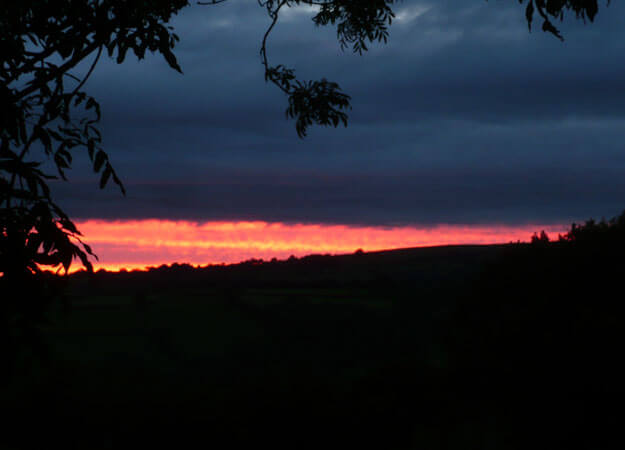
After a morning drizzle, the day promises to be much better than the previous one – I’m already looking forward to the warm sun beaming down upon me. I hang half of my kit on the outside of my rucksack to dry, at which point I am completely fascinated by the landscape again. Along the ‘Lyn y Fan Fawr’, the highest lake in South Wales, I follow the mountain range around ‘Fan Brycheiniog’ and reach my destination in the afternoon with a wonderful sunset over the gently rolling landscape of the Brecon Beacons, which had quite honestly put me through an emotional roller coaster up to that point.
The seventh and final day of my adventure had little to offer in the way of highlights. The route seems to have changed slightly before I had a chance to write this. In any case, I choose to do the “official” stages 7 and 8 together, treating myself to a wonderful 42km trek to the finish in the village of Bethlehem. With only a few metres of gain, ancient ruins and remnants of days gone by, the route allows for plenty of time to reflect. Exhausted but happy, I finally reach the wooden bench, which officially marks the finish of the Beacons Way. What now? It’s odd. I don’t know what I thought would happen when I arrived, so I sit down, eat my last chocolate bar, and eventually, I go on…


